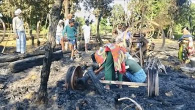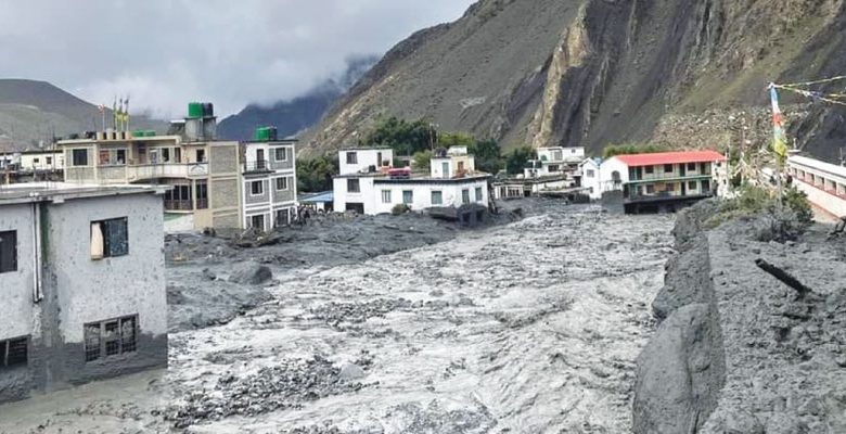
File photo: TRN Flood that occurred in Kagkhola, Mustang, three years ago.
By Phadindra Adhikari, Lekhnath, Sept. 5: A series of devastating floods in Gandaki Province has highlighted the region’s vulnerability to sudden, high-impact floods, with experts calling for detailed risk assessments, early warning systems and stronger land-use planning.
The Seti River flood in Kaski in April 2012 killed 72 people. Three years ago, the Kagkhola flood turned Kagbeni in Mustang into a riverbed, while floods in the Marsyangdi River and Timang Khola in Manang five years ago inundated Talgaon and swept away bridges and hydropower infrastructure.
These are among the recent examples of flash floods in Gandaki. Floods that develop within less than six hours and involve a rapid and substantial rise in water flow are generally referred to as flash floods. In the Himalayan region, they can be triggered by extreme rainfall, glacial lake outbursts, river blockages, dam failures, and falling masses of snow and ice.
As the full extent of the damage from the recent Bhotekoshi flood in Rasuwa, Dhading and Nuwakot is still being assessed, experts say Gandaki needs detailed research and practical disaster-response plans.
The sources of major rivers in the province—including the Kali Gandaki, Budhi Gandaki, Seti Gandaki, Marsyangdi, Madi, Daraundi and Trishuli—are in the mountains. The province also has several major tributaries and streams.
Glaciologist Dr. Rijan Bhakta Kayastha has argued that a major glacial flood around 450 years ago helped shape the present-day Pokhara Valley. Geographer Dr. Krishna KC also agrees that the region faces such risks.
“The risk of large masses of snow and ice falling near the source of the Seti has increased. If such masses fall between Machhapuchhre and Annapurna III and IV, they could reach the headwaters of the Seti and block the river,” KC said. Such a blockage could later trigger a flash flood when the river breaks through.
Geologist Basanta Raj Adhikari called for detailed hazard mapping and strategies based on local geography. “Natural disasters cannot be stopped, but we can learn to live according to our geography,” he said, stressing the need to identify where different types of floods could occur and prepare accordingly.
He said local governments should prepare annual programmes for early warning systems and prevent settlement development in high-risk areas.
Climate expert Dr. Subas Adhikari said Gandaki Province should identify its most vulnerable areas and enforce strict land-use regulations to prevent new settlements and critical infrastructure from being built along flood and landslide paths. He also stressed the need for cross-border cooperation, scientific diplomacy and regional research networks because the province’s major rivers originate in China and flow through Nepal into India.
The Bhotekoshi disaster has also raised new safety concerns for cities located along major rivers. Pokhara, in particular, faces significant risk from the Seti River.
Pokhara Metropolitan City Mayor Dhanraj Acharya said a geological study of the Pokhara Valley is currently being conducted with the involvement of foreign experts. “We will work to complete the study soon and, at the same time, implement disaster-resilient plans, precautionary measures and awareness programmes,” he said.
Dozens of settlements also lie along the Kali Gandaki River, including Jomsom, Chhusang, Marpha, Tukuche, Sauru, Kobang and Lete in Mustang; Beni, Tatopani and Pokharebagar in Myagdi; and Baglung Bazaar and Chapakot in Syangja.
Gharpajhong Rural Municipality, which includes Jomsom, is organising the Gharpajhong Climate 2083 conference on Bhadra 30 and 31 to discuss disaster preparedness, early warning and climate adaptation.
Similarly, Our Lamjung Correspondent Nabin Singh Kuinkel reported that concern is growing among residents and authorities after Dona glacial lake in Naso Rural Municipality-2 of Manang was identified as being at serious risk of an outburst.
The devastating Bhotekoshi flood in Rasuwa has prompted locals to call for an immediate assessment of the lake.
The lake has been listed among Nepal’s high-risk glacial lakes in studies conducted by the United Nations Development Programme (UNDP) and ICIMOD. Stakeholders have urged the government to carry out a detailed technical survey of its current condition.
Located in Nachai village at an elevation of around 4,100 metres above sea level, Dona is one of the glacial lakes considered a potential hazard in the Gandaki river basin.
Ravi Gurung, ward chairman of Naso-2, said the lake’s length has been increasing continuously, although its width has not changed significantly.
The lake is currently around 2,500 metres long and 700 metres wide, covering about 0.9 square kilometres, with a maximum depth of 82 metres.
Former minister Dev Gurung has also urged the government to immediately conduct an on-site survey and adopt a safety strategy, saying the lake has long been considered a potential threat but has not undergone a reliable survey.
An outburst from Dona could cause major damage to settlements, hydropower projects, bridges and other infrastructure along the Marsyangdi River. Several hydropower projects are already operating along the river, including the 75-MW Middle Marsyangdi, 69-MW Lower Marsyangdi and 50-MW Upper Marsyangdi-A projects. Other projects are under construction.
Naso Rural Municipality Chairman Dhan Bahadur Gurung said a project under the UNDP-supported climate risk adaptation and disaster risk reduction programme is planned to protect Dona Lake and establish an early warning system.
The Rising Nepal